Walking from Fushimi Inari-taisha to Heian Jingū

in Kyoto, Japan

6.38 km
85 minutes walking
AB
Fushimi Inari-taisha
AFushimi Inari-taishaWikidata ↗
Heian Jingū
BHeian JingūWikidata ↗

Standing at the entrance of Fushimi Inari-taisha, you’re greeted by the vibrant vermilion torii gates that seem to stretch endlessly up the mountain. The air is fresh, filled with the earthy scent of moss and damp wood, while the soft rustle of leaves and distant footsteps create a serene backdrop. You can hear the faint sound of a bell ringing from a nearby shrine, and the occasional call of a bird adds to the tranquil atmosphere.

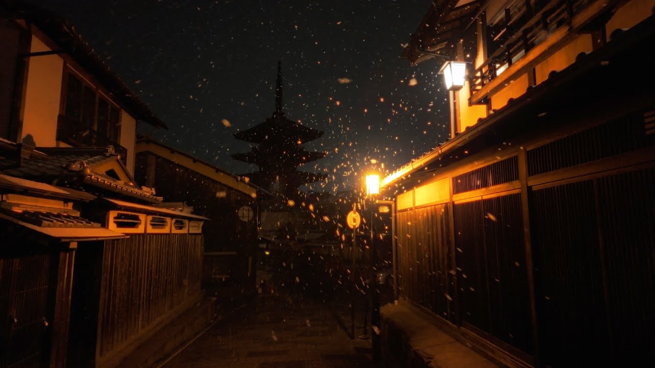
As you set off down Inariyama, the path begins to shift from the sacred tranquility of the shrine to the lively streets of Fushimi Ward. The terrain changes, with smooth pavements giving way to uneven cobblestones. You pass through narrow alleyways lined with quaint shops selling traditional snacks and sake, where the smell of grilling yakitori wafts through the air. Continuing onto Kiyomizu-zaka, the streets become steeper, and you might notice the sounds of laughter and chatter as locals and tourists mingle, their voices blending with the clatter of wooden sandals on stone.

Keep an eye out for the uneven surfaces as you navigate the cobblestones. The area can get busy, especially during peak hours, so be cautious of bicycles zipping by. Some shops may close earlier than you expect, so if you want to stop for a snack, plan accordingly. Also, be mindful of your belongings, as pickpockets can sometimes be a concern in crowded places.

Wear comfortable shoes, as this walk involves a bit of uphill and downhill trek. It's a good idea to bring a water bottle, especially in the summer heat, and maybe a small umbrella or jacket if you're walking in the rainy season. Early morning or late afternoon is perfect for this route, as the light softens and the temperatures are more pleasant.

The best moment of this walk happens as you approach Heian Jingū, when you catch a glimpse of the large torii gate framing the entrance to the shrine. The sight, especially during the golden hour, is striking. The soft pink of cherry blossoms swaying gently in the breeze fills the air with a sweet, floral scent that lingers as you stand there, taking it all in.

Turn-by-turn directions

26 steps · pace ~4.5 km/h
  1. Set off
    34 m
    27 s
  2. Take a left
    85 m
    1 min
    0.12 / 6.38 km · 2%
  3. Hang a right onto 神幸道
    160 m
    2 min
    0.28 / 6.38 km · 4%
  4. 💧First quarter done. If it's hot, a sip of water now beats a gulp later.
  5. Hang a right onto 本町通
    Long stretch ahead - photo break, phone check, or just look around.
    1.41 km
    19 min
    1.69 / 6.38 km · 26%
  6. Take a left
    29 m
    23 s
    1.72 / 6.38 km · 27%
  7. Turn right at the end of the road
    Long stretch ahead - photo break, phone check, or just look around.
    1.07 km
    14 min
    2.79 / 6.38 km · 44%
  8. 🏁Halfway. Good moment to refill water or grab a quick coffee if you see one.
  9. Hang a right
    Long stretch ahead - photo break, phone check, or just look around.
    594 m
    8 min
    3.38 / 6.38 km · 53%
  10. Turn slight right
    45 m
    36 s
    3.43 / 6.38 km · 54%
  11. Hang a right
    73 m
    59 s
    3.50 / 6.38 km · 55%
  12. Turn slight right
    Long stretch ahead - photo break, phone check, or just look around.
    705 m
    9 min
    4.21 / 6.38 km · 66%
  13. Turn left at the end of the road
    Use this stretch to catch your breath if the next turn looks busy.
    352 m
    5 min
    4.56 / 6.38 km · 71%
  14. 🪜Three quarters. Legs may start protesting - the next bench is fair game.
  15. Keep slight left at the fork
    Use this stretch to catch your breath if the next turn looks busy.
    279 m
    4 min
    4.84 / 6.38 km · 76%
  16. Turn right at the end of the road
    54 m
    43 s
    4.89 / 6.38 km · 77%
  17. Hang a slight left
    94 m
    1 min
    4.99 / 6.38 km · 78%
  18. Hang a sharp right
    Use this stretch to catch your breath if the next turn looks busy.
    299 m
    4 min
    5.28 / 6.38 km · 83%
  19. Hang a right
    89 m
    1 min
    5.37 / 6.38 km · 84%
  20. Take a left
    65 m
    52 s
    5.44 / 6.38 km · 85%
  21. Keep slight right onto 水車の竹中径 at the fork
    84 m
    1 min
    5.52 / 6.38 km · 87%
  22. Take a left
    102 m
    1 min
    5.62 / 6.38 km · 88%
  23. Hang a right
    30 m
    24 s
    5.65 / 6.38 km · 89%
  24. 📍Almost there. Look up - you should be able to spot the destination soon.
  25. Take a left
    236 m
    3 min
    5.89 / 6.38 km · 92%
  26. Take a left onto 神宮道
    140 m
    2 min
    6.03 / 6.38 km · 95%
  27. Turn left at the end of the road
    96 m
    1 min
    6.13 / 6.38 km · 96%
  28. Turn left at the end of the road
    176 m
    2 min
    6.30 / 6.38 km · 99%
  29. Take a left
    Final stretch. Slow down so you don't walk past the entrance.
    79 m
    1 min
    6.38 / 6.38 km · 100%
  30. 🏁
    Arrive at destination

Local-script names show how they're signposted. The ≈ line shows a rough Latin transliteration to help with pronunciation. Times assume a steady ~5 km/h walk; add 15-20% in summer heat, on hills, or in crowds.

Open in the planner Customise this route or add more stops →
See Kyoto street previews

Watch Kyoto streets before you walk

Ambient first-person walking videos of Kyoto. Same streets, real sound. Pick a season or time-of-day to preview the route.

Watch Kyoto during the day
day · during the day
Watch Kyoto during the day
Watch Kyoto at night
night · at night
Watch Kyoto at night
Watch Kyoto in spring
spring · in spring
Watch Kyoto in spring

Other walking routes in Kyoto

Share this route

WhatsAppTelegramFacebookXRedditLinkedInEmail

Frequently asked questions

How long does it take to walk from Fushimi Inari-taisha to Heian Jingū?

About 85 minutes at a steady 4.5 km/h walking pace. Add 15-20% in summer heat, on hills, or if you stop for photos.

How far is Fushimi Inari-taisha from Heian Jingū on foot?

The walking route is 6.38 km following pedestrian paths. The straight-line distance is shorter but ignores buildings and one-way streets.

Is this walk suitable for casual walkers?

This 6.38 km route is an longer walk - bring water and pace yourself. The pedestrian path uses footpaths and side streets where possible, so it's safer than walking along main roads.

What streets does the route pass through?

The route in Kyoto passes through 神幸道, 本町通, 水車の竹中径, 神宮道. Street names are signposted in the local language.

What's the best time of day to walk this route?

For the best atmosphere on this stretch of Kyoto, the day walking video gives the most accurate preview of light and crowds. In general, early morning or sunset minimises midday heat and gives softer light for photos.

Is the walking route free?

Yes - planning, viewing the route, and using our directions are all free. Watch out for paid entry to any specific landmark on the route (museums, archaeological sites) - those are separate from the walk itself.

Can I reverse the route and walk from Heian Jingū back to Fushimi Inari-taisha?

Yes - the same path works in reverse with the same distance and walking time. Some one-way streets only affect drivers, not pedestrians.

Walking pace assumed at about 5 km/h on level ground - hills, crowds, and stops will slow you down.

Walking-route geometry from OpenStreetMap contributors via FOSSGIS OSRM (data licensed under ODbL). Landmark data from Wikidata (CC0).