enesfrdeitpt

Walking from Sidi Saiyyed Mosque to Sidi Bashir Mosque

in Ahmedabad, India

3.54 km
47 minutes walking
AB
Sidi Saiyyed Mosque
ASidi Saiyyed MosqueWikidata ↗
Sidi Bashir Mosque
BSidi Bashir MosqueWikidata ↗

Standing outside the Sidi Saiyyed Mosque, I’m greeted by the intricate lattice work of the stone façade, sunlight filtering through the delicate patterns. The scent of street food wafts through the air, mingling with the faint sounds of chatter and the honking of rickshaws. As I take in the scene, vendors arrange colorful wares on the ground, their calls punctuating the atmosphere. You can feel the pulse of the city surrounding you, urging you to explore further.

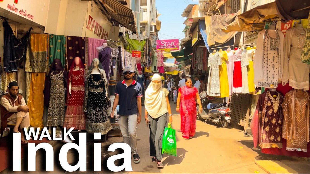
Leaving the mosque, you’ll walk along the narrow lanes of the old city, where the terrain shifts from smooth pavements to uneven cobblestones. The streets of Manek Chowk come alive with sounds of sizzling snacks being fried and the chatter of locals bargaining over fresh produce. As you head towards the Sidi Bashir Mosque, the density of the area increases, with small shops lining the streets. The light changes too, with the sun casting long shadows as buildings create pockets of shade that feel cooler against the heat of the day.

Watch your step, as the cobbled streets can be quite steep and uneven in places, making it easy to trip if you’re not paying attention. Traffic can be chaotic, so keep an eye on the roads as you navigate through the throngs of people. Be wary of pickpockets in busier areas, and if you're planning to visit during midday, remember that many shops may close for a few hours, so timing is key.

For this walk, comfortable footwear is essential; you'll be traversing uneven surfaces and possibly dodging rickshaws. Bring a bottle of water to stay hydrated, especially if it’s a hot day, and consider sunscreen or an umbrella for shade. Depending on the season, mornings or late afternoons are ideal to avoid the harsh midday sun.

The best moment of this walk comes just before sunset, as the light softens and paints the sky in hues of orange and pink. Standing in front of the Sidi Bashir Mosque, you can hear the distant sounds of evening prayers, the air cooling around you, and the faint aroma of the spices from nearby food stalls. It’s a moment that captures the essence of the city, rich with life and warmth.

Turn-by-turn directions

11 steps · pace ~4.5 km/h
  1. Set off
    45 m
    36 s
  2. Take a left
    72 m
    58 s
    0.12 / 3.54 km · 3%
  3. 💧First quarter done. If it's hot, a sip of water now beats a gulp later.
  4. Turn left onto Relief Road
    Long stretch ahead - photo break, phone check, or just look around.
    1.30 km
    17 min
    1.42 / 3.54 km · 40%
  5. 🏁Halfway. Good moment to refill water or grab a quick coffee if you see one.
  6. Turn left onto Gheekanta Road
    Long stretch ahead - photo break, phone check, or just look around.
    578 m
    8 min
    2.00 / 3.54 km · 56%
  7. Carry on along Gheekanta Road
    48 m
    39 s
    2.04 / 3.54 km · 58%
  8. Take a slight left onto Naroda Road
    Use this stretch to catch your breath if the next turn looks busy.
    298 m
    4 min
    2.34 / 3.54 km · 66%
  9. Carry straight onto Kalupur Overbridge
    230 m
    3 min
    2.57 / 3.54 km · 73%
  10. 🪜Three quarters. Legs may start protesting - the next bench is fair game.
  11. Take a right onto Manubhai Parmar Overbridge
    220 m
    3 min
    2.79 / 3.54 km · 79%
  12. 📍Almost there. Look up - you should be able to spot the destination soon.
  13. Hang a right
    Long stretch ahead - photo break, phone check, or just look around.
    582 m
    8 min
    3.37 / 3.54 km · 95%
  14. Hang a sharp right
    Tight corner - watch for cyclists cutting it close.
    170 m
    2 min
    3.54 / 3.54 km · 100%
  15. 🏁
    Arrive at destination

Local-script names show how they're signposted. The ≈ line shows a rough Latin transliteration to help with pronunciation. Times assume a steady ~5 km/h walk; add 15-20% in summer heat, on hills, or in crowds.

Open in the planner Customise this route or add more stops →
See Ahmedabad street previews

Watch Ahmedabad streets before you walk

Ambient first-person walking videos of Ahmedabad. Same streets, real sound. Pick a season or time-of-day to preview the route.

Watch Ahmedabad during the day
day · during the day
Watch Ahmedabad during the day
Watch Ahmedabad at night
night · at night
Watch Ahmedabad at night
Watch Ahmedabad in summer
summer · in summer
Watch Ahmedabad in summer

Other walking routes in Ahmedabad

Share this route

WhatsAppTelegramFacebookXRedditLinkedInEmail

Frequently asked questions

How long does it take to walk from Sidi Saiyyed Mosque to Sidi Bashir Mosque?

About 47 minutes at a steady 4.5 km/h walking pace. Add 15-20% in summer heat, on hills, or if you stop for photos.

How far is Sidi Saiyyed Mosque from Sidi Bashir Mosque on foot?

The walking route is 3.54 km following pedestrian paths. The straight-line distance is shorter but ignores buildings and one-way streets.

Is this walk suitable for casual walkers?

This 3.54 km route is an longer walk - bring water and pace yourself. The pedestrian path uses footpaths and side streets where possible, so it's safer than walking along main roads.

What streets does the route pass through?

The route in Ahmedabad passes through Relief Road, Gheekanta Road, Naroda Road, Kalupur Overbridge and others. Street names are signposted in the local language.

What's the best time of day to walk this route?

For the best atmosphere on this stretch of Ahmedabad, the day walking video gives the most accurate preview of light and crowds. In general, early morning or sunset minimises midday heat and gives softer light for photos.

Is the walking route free?

Yes - planning, viewing the route, and using our directions are all free. Watch out for paid entry to any specific landmark on the route (museums, archaeological sites) - those are separate from the walk itself.

Can I reverse the route and walk from Sidi Bashir Mosque back to Sidi Saiyyed Mosque?

Yes - the same path works in reverse with the same distance and walking time. Some one-way streets only affect drivers, not pedestrians.

Walking pace assumed at about 5 km/h on level ground - hills, crowds, and stops will slow you down.

Walking-route geometry from OpenStreetMap contributors via FOSSGIS OSRM (data licensed under ODbL). Landmark data from Wikidata (CC0).